 Sept. 28, 2009---What a long, windy-windy day!
The sun was just beginning to rise above the trees as we left Harpeth River at mile 153.0 and continued down river on the Cumberland.
Reached Cheatham Lock and dam at mile 148.7. Construction on this dam began in 1950 and lake fillage began in late 1953. Maximim width of the dam is 800' and max height is 75'. Lift is 26'.

The first power plant at Cheatham went into operation in 1959.
Lots of water flowing over the dam from all the rain in the past two weeks.
Reached Clarksville at mile 126.
There are probably many historic things to see in Clarksville, but for now we just waved as we passed by the RiverCenter.
Tennessee Valley Authority's Cumberland steam plant at mile 103. This plant uses pulverized coal to generate 2.6 gigawatts of electricty, the most of any of the plants on TVA's system..

First class house boat!
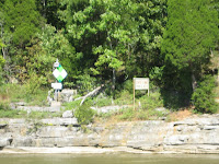
Glare made reading the rectangular sign a little difficult. It identifies the Tennesse-Kentucky state line at day marker 74.7 on the Cumberland River.

Just for information a picture of the chart plotter shows Lineport Landing Light and Daymark. It is the black square behind the boat on the right. That is the state line. Notice the water depth is 55.8', speed is 10.9 MPH and the magnetic heading is 338 degrees.
The wind blew hard all day Often making white caps on Barkley Lake. The current was strong all day. Appeared to average about 2 MPH which really helped on fuel economy and distance covered. Since we got an early start at 6:45 a.m., we chose to travel 98.2 miles and turn starboard at mile marker 54.8 into Hurricane Creek. Prizer Point Marina and Resort is about 1/2 mile up the creek where we tied up at 4:45 p.m. A long 10 hours in the wind and rough water as described by Marryann in the video.


No comments:
Post a Comment